When you measure water velocity from a moving vessel, the ADCP records the velocity of the water relative to the instrument. But the instrument itself is moving — carried by the boat, drifting with currents, or bobbing on a mooring. To obtain the true water velocity — the velocity that would be measured by a stationary instrument at the same location — you must subtract the instrument’s own motion. This subtraction is only as good as the motion measurement, and there are two fundamentally different ways to measure that motion: bottom tracking and GPS referencing. Each has distinct strengths, failure modes, and blind spots.
How Bottom Tracking Works
Bottom tracking uses a dedicated acoustic ping — separate from the water-profiling ping, and typically at a lower frequency to maximize range — that reflects off the stationary seabed. Because the seabed is not moving, any measured Doppler shift is due entirely to the instrument’s motion relative to the bottom. This motion vector is then subtracted from the water-profiling measurements to produce the true water velocity. The measurement is elegant, self-contained, and requires no external equipment — the same transducer that profiles the water also tracks the bottom.
Bottom tracking works reliably when several conditions are met: the water depth is within the instrument’s bottom-tracking range (typically 80–90% of the water-profiling range for a given frequency), the seabed is hard and reasonably flat, and the bottom material reflects acoustic energy efficiently. Under these conditions — common for river gauging and coastal surveys over sand, gravel, or rock — bottom tracking provides a direct, high-accuracy velocity reference.
When Bottom Tracking Fails
Bottom tracking has several well-characterized failure modes that every ADCP operator should recognize:
Soft sediment: Mud, silt, and fine organic material absorb acoustic energy rather than reflecting it. The bottom-tracking return signal is weak or absent, and the instrument cannot compute a reliable bottom velocity. This is common in estuarine environments, harbor basins, and deep basins with fine-grained deposition. The instrument may report a bottom-track velocity with low correlation — if the correlation drops below the manufacturer’s recommended threshold (typically 0.8–0.9), the measurement is unreliable and should not be used.
Steep bathymetry: On a steep slope, the bottom-tracking beam may reflect away from the transducer rather than back toward it — the acoustic equivalent of a mirror reflecting light away from the viewer. This is common at channel edges, canyon walls, and artificial structures like breakwaters.
Moving bottom: In rivers with high sediment transport, the bed itself is moving — sand dunes migrate, gravel rolls, and suspended sediment near the bed forms a dense layer that moves at some fraction of the water velocity. The bottom tracker measures the velocity of this moving layer, not the stationary bed, producing a water velocity that is biased low. This is a particular problem for river discharge measurements in sand-bed channels and during flood events.
Beyond range: In water deeper than the bottom-tracking limit, the acoustic signal attenuates before reaching the seabed, and no bottom return is detected. Deep-water ADCP surveys always require GPS referencing for this reason.
How GPS Referencing Works
GPS referencing measures the vessel’s motion independently of the ADCP using satellite positioning. A GPS antenna mounted directly above the ADCP transducer records the antenna’s position at 1–10 Hz. The change in position over time gives the vessel’s velocity, which is subtracted from the ADCP-measured water velocity.
The critical advantage of GPS referencing is that it works regardless of water depth, seabed type, or bathymetry. It does not care whether the bottom is hard rock, soft mud, or five kilometers deep. It also avoids the moving-bottom problem entirely, because GPS measures the vessel’s motion in an Earth-fixed reference frame, not the relative motion between vessel and seabed.
The disadvantage is accuracy. Standard GPS velocity measurements have an uncertainty of approximately 0.1 m/s — adequate for mean current measurements in tidal streams and coastal waters, but marginal for high-accuracy discharge measurements where velocity uncertainties of 0.01 m/s are desired. RTK (Real-Time Kinematic) GPS improves this to approximately 0.02 m/s by using a fixed base station to correct for atmospheric and satellite errors in real time. For discharge measurements intended to be within 5% accuracy, RTK GPS is strongly recommended over standard GPS.
Practical Decision Guide: Which Method to Use When
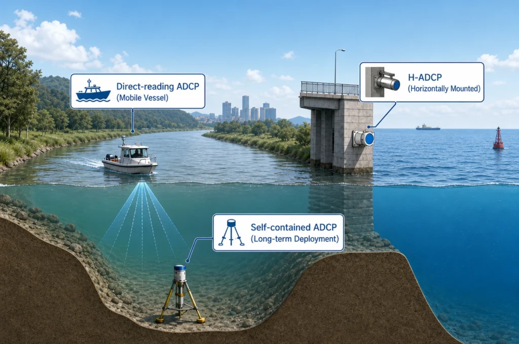
Use bottom tracking when: the seabed is within range, the bottom material is hard and reflective (sand, gravel, rock), the bed is not moving, and bathymetry is reasonably flat. This covers most river discharge measurements in gravel-bed and bedrock channels, most coastal surveys over sand bottoms, and any deployment where a self-contained velocity reference is preferred.
Use GPS referencing when: the water depth exceeds bottom-tracking range, the seabed is soft or steep, you suspect moving-bed conditions, or you are measuring from a platform that is not in contact with the bottom (drifting buoy, ice floe, autonomous surface vehicle). GPS is mandatory for deep-water surveys and strongly recommended for sand-bed river channels where moving-bottom bias may be significant.
Use both when: you want the most robust measurement possible. Many modern ADCPs — including Oceantek’s direct-reading series — support simultaneous bottom tracking and GPS input. The acquisition software can display both velocity references in real time, allowing the operator to identify discrepancies between them. A systematic difference between bottom-track and GPS velocities in shallow water is a strong indicator of moving-bed conditions — information that is itself valuable for understanding sediment transport at the site.
For detailed guidance on configuring navigation methods for your specific survey type, see our ADCP parameter selection guide.