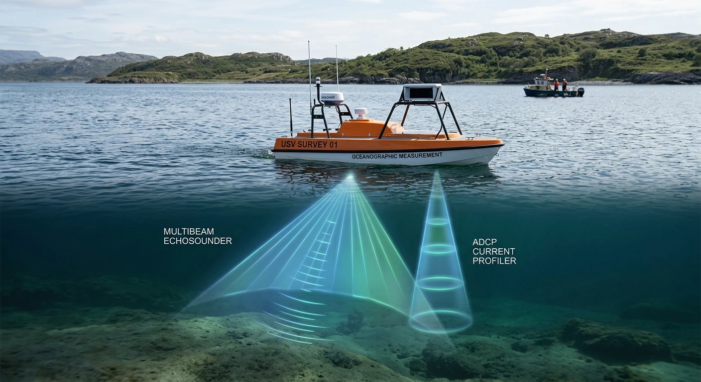
In hydrographic surveying, understanding the underwater environment has historically been a two-dimensional challenge. For decades, legacy hydrographic instruments focused almost entirely on mapping topography—answering the question, “What does the bottom look like?” Standard single-beam and multi-beam echosounders (MBES) revolutionized our view of bathymetry, yet they left a critical blind spot in the water column itself: hydrodynamics.
Water is an inherently dynamic, multi-layered system. Relying solely on static bathymetric mapping or archaic, single-point mechanical current meters introduces significant blind spots into modern survey operations. Whether you are managing port dredging projects, monitoring flood risks, or deploying autonomous survey platforms, knowing how the water moves is just as vital as knowing its depth.
This is where the Acoustic Doppler Current Profiler (ADCP) becomes indispensable. Rather than operating as an isolated tool, a modern ADCP serves as the core dynamic engine within integrated hydrographic survey systems.
1. Unveiling the Third Dimension: High-Resolution 3D Current Profiling
Traditional current meters measure water velocity at a single localized point, failing to capture the complex, stratified layers of open water. In environments like tidal estuaries, shipping channels, or offshore construction sites, fluid dynamics are rarely uniform.
An ADCP utilizes the Doppler shift principle by emitting acoustic pulses and measuring the frequency shift of the backscattered signal from moving particles in the water. By dividing the water column into discrete vertical segments known as depth bins, the ADCP maps high-resolution 3D current profiling data (North, East, and Vertical vectors) simultaneously across the entire water column.
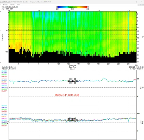
Figure 1 : Acoustic backscatter analysis and 3D current profiling software visualization from an Oceantek ADCP sensor.
The Cost of Failure Without 3D Profiling:
In busy ports, a major hidden operational risk is current shear—a phenomenon where surface currents move in one direction while deeper currents flow in another, often due to thermal stratification or benthic topography. If a hydrographic survey system only captures surface velocity, a 15,000 TEU container vessel navigating a narrow channel could encounter unexpected deep-water forces, leading to catastrophic steering deviations, grounding risks, and steep maritime liability costs.
2. Revolutionizing River Gauging: Real-Time Transect Discharge Measurement
For hydrologists and water resource authorities, measuring river discharge or streamflow gauging has traditionally been a hazardous, labor-intensive ordeal. The legacy “cup-and-vane” method required field crews to lower mechanical rotors at multiple stationary points across a river cross-section—a process taking hours and exposing personnel to hazardous conditions.
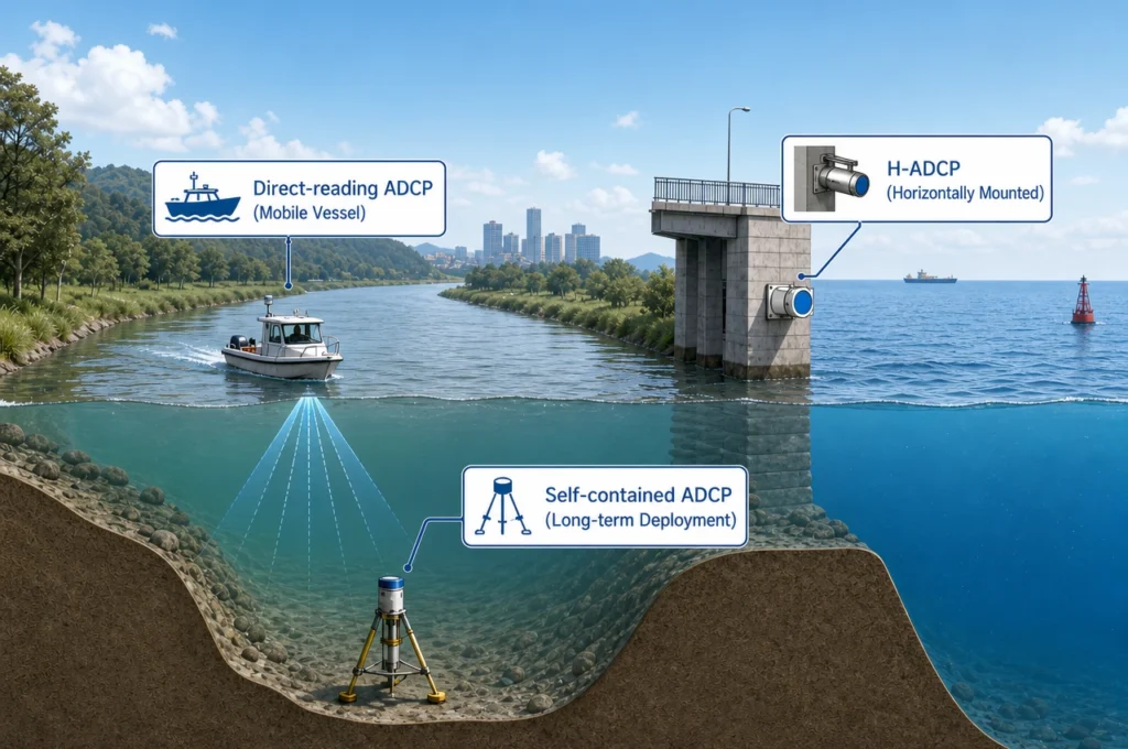
Modern hydrographic survey systems overcome this bottleneck by integrating an ADCP into a moving boat or an Unmanned Surface Vehicle (USV). Using the moving-boat method, the survey vessel transits from one bank to the other just once. The ADCP continuously logs depth, track, and velocity profiles, calculating total river discharge measurement in real-time within minutes.
Regulatory & International Standards Compliance
Modern water management requires strict adherence to data quality standards. Utilizing the ADCP moving-boat methodology for streamflow and discharge calculation aligns seamlessly with international technical standards, specifically ISO 748 (Hydrometry — Measurement of liquid flow in open channels) and USGS (U.S. Geological Survey) Quality-Assurance Plans for acoustic discharge measurements.
This rapid data acquisition is critical during extreme weather events. When tracking a flash flood peak, the measurement window lasts only a few hours. Legacy methods fail to capture the peak, whereas an Oceantek ADCP allows operators to capture highly transient hydrodynamic data safely and efficiently.
3. Dual-Purpose Acoustics: Sediment Transport & Acoustic Backscatter Inversion
A common misconception is that an ADCP is exclusively a current-measuring tool. In reality, the acoustic signals returning to the transducers carry a wealth of secondary information. The strength of the returning signal—known as acoustic backscatter analysis—is directly influenced by the concentration and size of particles suspended in the water column.
Through advanced software algorithms and backscatter inversion, hydrographic survey systems can translate these raw acoustic decibel returns into precise estimates of Suspended Sediment Concentration (SSC).
The Engineering & ROI Advantage:
In port maintenance and dredging projects, understanding sediment transport monitoring is highly lucrative. Dredging companies face massive financial losses if an excavated channel is immediately refilled by natural sediment migrations. By utilizing an ADCP, project managers achieve dual-purpose utility from a single sensor. They map current dynamics and sediment trends simultaneously, eliminating the need to deploy separate, expensive optical turbidity sensors or gather endless manual bottle samples. This drastically optimizes project return on investment (ROI).
4. The Ultimate Redundancy: Bottom Tracking in GNSS-Denied Environments
Modern hydrographic surveys heavily rely on high-precision RTK-GNSS (Real-Time Kinematic Global Navigation Satellite Systems) for spatial positioning. However, satellite positioning systems possess an inherent vulnerability: they require an unobstructed line of sight to the sky.
When a survey vessel enters a GNSS-denied environment—such as navigating under massive steel-girded bridges, inside deep river canyons, through urban waterways, or under dense jungle canopies—satellite signals suffer from severe multipath errors or cut out entirely. Without a secondary positioning reference, the mapped data drifts spatially, rendering the survey useless.
Modern ADCPs counteract this vulnerability via bottom tracking. The instrument fires dedicated acoustic pings straight to the seabed or riverbed. By measuring the Doppler shift relative to the solid bottom, the ADCP calculates the vessel’s exact Speed Over Ground (SOG) and course independently of satellites. When fused with an Inertial Measurement Unit (IMU), it enables accurate dead reckoning navigation, ensuring that even when GPS is completely lost, the hydrographic system continues to pinpoint coordinates flawlessly.
Future-Proofing Hydrography: The USV and SWaP Revolution with Oceantek
As the maritime sector shifts toward automation, the trend in modern hydrographic survey systems is the rapid adoption of Unmanned Surface Vehicles (USVs) and remote autonomous platforms. For a USV, sensor payloads must conform to strict SWaP (Size, Weight, and Power) constraints. System integrators can no longer afford bulky, power-hungry electronics that drain battery reserves and limit field deployment windows.
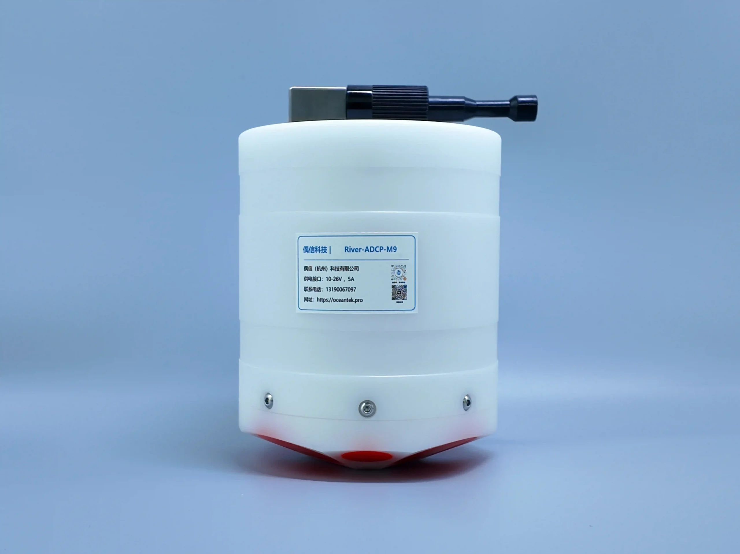
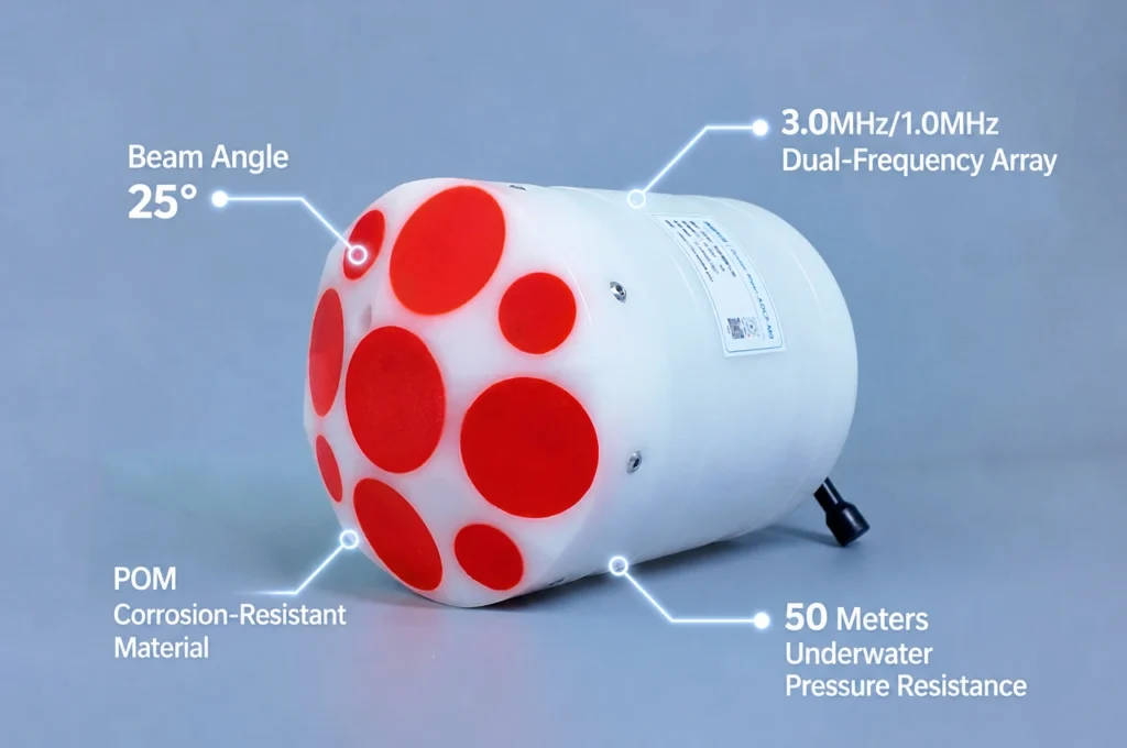
Figure 2 : Compact Oceantek ADCP optimized for SWaP constraints
Recognizing this industry shift, Oceantek has engineered the next generation of acoustic Doppler current profilers designed specifically for seamless system integration.
Whether you are conducting shallow-water river gauging or hydrographic mapping, the Oceantek River ADCP M9 delivers research-grade accuracy without compromising your platform’s operational efficiency.
Why Hydrographers Choose Oceantek ADCPs:
- Optimized for Autonomous Platforms: Featuring an ultra-compact form factor and industry-leading low power consumption, our sensors integrate flawlessly into diverse Oceantek USV Integration Solutions without sacrificing vehicle endurance.
- Multi-Frequency Versatility: From high-resolution shallow-water depth bins to deep-water profiling, the Oceantek Vessel-Mounted ADCP Series provides the frequency flexibility required for diverse environmental constraints.
- Turnkey Compliance: Engineered to output data that fully satisfies ISO 748 and USGS quality assurance standards, ensuring your data is ready for regulatory approval straight out of the box.
Elevate Your Hydrographic System with Oceantek
Don’t let your hydrographic survey system operate with a blind spot in the water column. Transition from basic 2D bathymetry to comprehensive, multi-dimensional hydrodynamic modeling with Oceantek’s proven acoustic technology.
Ready to upgrade your survey capabilities?
- Explore our complete lineup on the official Oceantek ADCP Product Portfolio Page.
- Contact an Oceantek Application Engineer Today to request a customized integration blueprint or a technical quote for your next project.