River flow measurement is a cornerstone of modern hydrology. It supports flood forecasting, water resource management, and ecological monitoring. These tasks are more critical than ever. Yet accurate flow measurement has always been challenging. Traditional methods often fail when they are needed most. This guide explores the evolution of river flow measurement. It explains the benefits of ADCP technology. It covers installation techniques and data interpretation. Finally, it introduces the Oceantek River-ADCP-M9. This new instrument sets a new standard for river monitoring.
The Challenges of Traditional River Flow Measurement
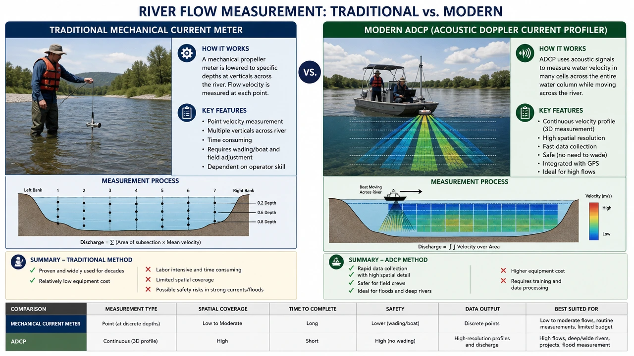
For over a century, hydrologists relied on mechanical current meters. These devices use a propeller that rotates in flowing water. The rotation speed indicates the water velocity. This principle is simple. However, it has serious limitations.
Mechanical meters require a minimum velocity to start moving. The friction in their bearings creates unavoidable startup resistance. As a result, flows below this threshold are not recorded. Readings become distorted at low speeds. Moreover, conventional techniques are time-consuming and labor-intensive. Field crews must take point measurements at multiple verticals across the river. A complete discharge measurement can take hours. During floods, when data matters most, these methods become unsafe or impossible.
Furthermore, traditional approaches offer only sparse data. They capture velocity at a few discrete points. The rest of the flow field remains unknown. This limits understanding of complex river dynamics. Modern water management demands better solutions. Acoustic Doppler technology fills this gap.
Why Use ADCP in River Monitoring?
Acoustic Doppler Current Profilers, or ADCPs, have transformed river measurement. They use the Doppler principle to measure water velocity. The instrument emits sound pulses at a known frequency. These pulses reflect off particles suspended in the water. The frequency shift reveals the velocity of the water along each beam.
ADCPs offer several clear advantages over traditional methods. First, they measure the entire water column. Instead of a few point readings, users get a complete velocity profile. This profile covers the river from surface to bed. Second, ADCP measurements are remarkably fast. A complete cross-section survey can be done in minutes. Traditional methods take much longer. Third, ADCPs handle challenging conditions well. They work effectively in unsteady flows, tidal reaches, and flood situations. Finally, these instruments provide rich datasets. Users obtain three-dimensional velocity components, bathymetry, and discharge in a single survey. This data density supports better hydrological analysis.
Modern ADCPs are also highly portable. Units can be mounted on small boats or uncrewed surface vessels. This flexibility opens up measurement sites that were previously inaccessible. The technology has matured significantly since its early days. Today, ADCPs are the standard tool for river discharge measurement worldwide.
What are Installation Methods for River ADCP?
Choosing the right installation method is essential. The approach depends on the monitoring objective, site conditions, and available resources. Two broad categories exist: mobile surveys and fixed deployments.
Mobile (Moving-Boat) Surveys
Mobile surveys are the most common ADCP application. The instrument mounts to a manned boat, a tethered raft, or an uncrewed surface vessel. The platform moves across the river perpendicular to the flow. The ADCP measures velocity profiles continuously. Bottom tracking or GPS provides vessel position. Combined, these data yield the total discharge through the cross-section.
This method is ideal for periodic discharge measurements. It suits rivers of all sizes. Setup is quick, and the workflow is efficient. However, attention to detail is needed. The boat speed should not exceed the water speed. The transect should be as straight as possible. A moving-bed test is recommended before beginning.
Fixed (Stationary) Deployments
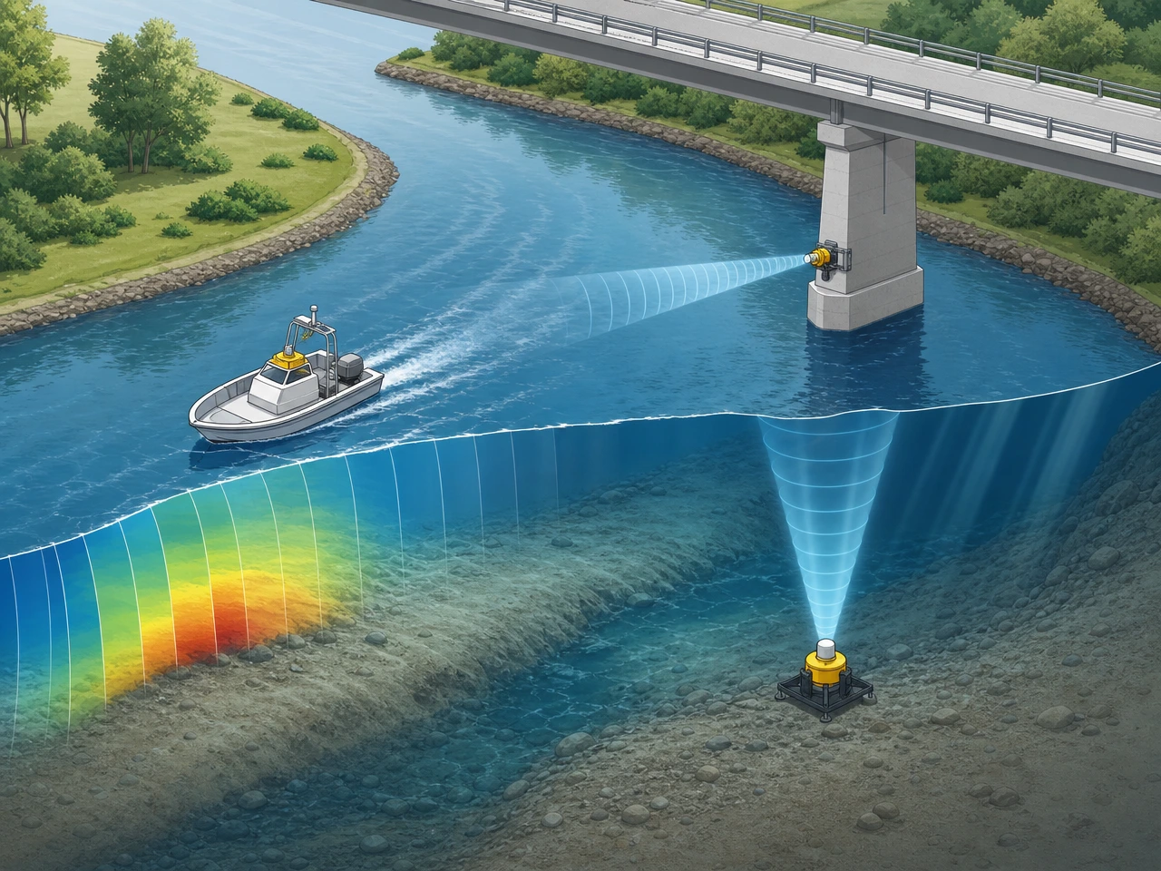
Fixed deployments are used for long-term continuous monitoring. In this configuration, the ADCP is mounted permanently at a selected location. Side-looking installations are common. The instrument attaches to a bridge pier or a bank structure. Its beam is aimed horizontally across the channel. Bottom-mounted frames can also be used. These sit on the riverbed and measure upward through the water column.
Fixed deployments provide continuous data over weeks or months. This is valuable for understanding seasonal variations and flood events. Proper installation is critical. The mounting must be rigid. The pitch and roll should be near zero. The heading must be calibrated correctly. Cables must be protected from debris and animals. In environments with high sediment loads, regular maintenance is needed. The instrument face must stay clean for accurate measurements.
Installation planning should account for the lowest expected water level. The sensor must remain submerged at all times. Cross-section geometry must also be verified. A strong acoustic reflection from the opposite bank is essential for range-gated velocity measurements.
Data Interpretation: From Raw Signal to Actionable Insight
ADCP data interpretation requires care. The raw output includes beam velocities, signal strength, and correlation values. Quality control is the first step in any analysis.
Correlation is a key quality indicator. It measures the consistency of the Doppler shift estimate. Low correlation suggests unreliable data. Values above 70% are generally acceptable. Signal strength indicates the number of scatterers in the water. A sudden drop may mean the beam is hitting the surface or bed. Echo intensity can also be used for suspended sediment studies.
Velocity data must be screened for errors. Spikes can occur due to fish, debris, or turbulence. Automated filters help remove these outliers. The error velocity, derived from redundant beams, shows internal consistency. High error velocity suggests invalid measurements. After screening, the velocity profiles are integrated with cross-section area to compute discharge.
Water level data completes the picture. For fixed stations, stage-discharge rating curves are developed over time. These curves relate water level to flow. They provide continuous discharge estimates from stage readings alone. For mobile surveys, GPS-derived water surface elevation adds context. Modern software packages streamline this process. They generate reports with velocity contours, discharge summaries, and quality metrics. Understanding these tools is part of the hydrologist’s craft.
The final step is documentation. Each measurement should include metadata. Site conditions, instrument settings, and quality flags must be recorded. This transparency supports E-E-A-T in hydrological reporting. It allows others to evaluate the data critically.
Oceantek River-ADCP-M9: Next-Generation River Profiling
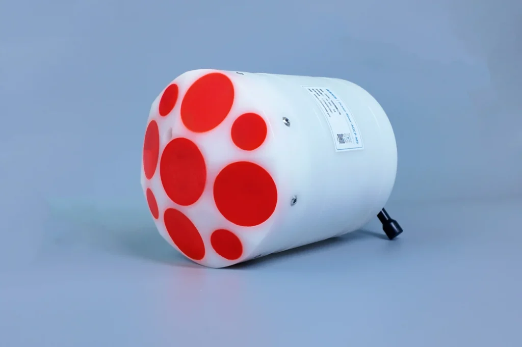
Oceantek Marine Technologies has released a new river ADCP. The River-ADCP-M9 is designed specifically for complex river environments. It combines advanced acoustics with rugged engineering. The result is an instrument that excels where traditional devices struggle.
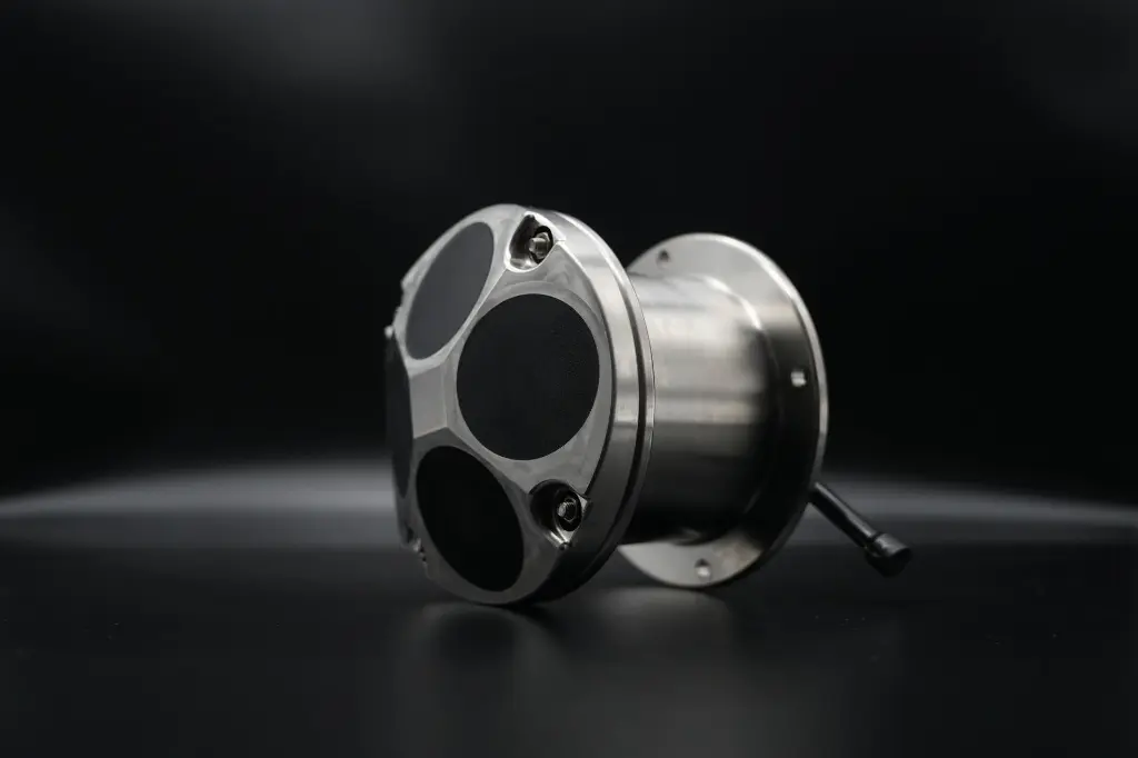
Nine-Beam Architecture
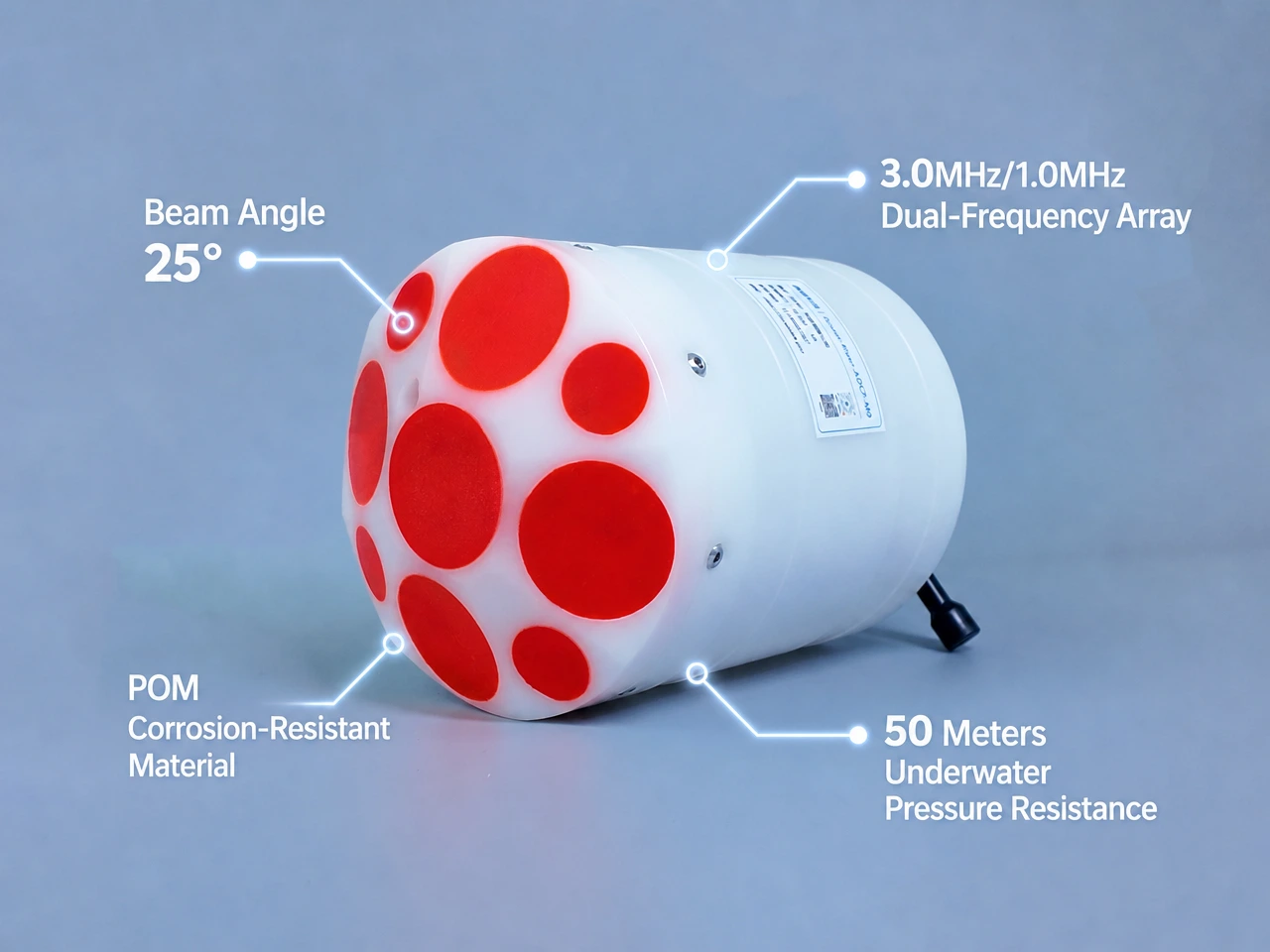
The defining feature of the M9 is its nine-beam system. It integrates dual 4-beam Janus arrays at 3.0 MHz and 1.0 MHz. A dedicated 0.5 MHz vertical beam handles depth sounding. This multi-frequency approach covers all measurement scenarios. The high-frequency beams deliver high resolution in shallow water. The low-frequency beams provide strong penetration in deeper, turbid flows. The vertical beam offers precise bathymetry independent of the slant beams. The 25° beam angle optimizes horizontal coverage and minimizes side-lobe interference.
Industry-Leading Precision
The M9 delivers measurement accuracy that meets the highest standards. Its velocity precision reaches ±0.25% ±2 mm/s. Velocity resolution is 1 mm/s. This level of detail captures subtle flow features, including slow-moving eddies and boundary layer structures. The velocity range spans ±20 m/s in any direction. Flow direction accuracy is ±2° across the full 360-degree range. Depth measurement resolution is 0.001 m, with accuracy of 1% of reading. These specifications are fully competitive with top-tier imported instruments. Independent side-by-side tests in the Yangtze River, Yellow River, and Fuzhou coastal waters show results that closely match those from imported equipment.
Comprehensive Sensor Suite
Beyond velocity, the M9 carries an integrated sensor package. A temperature sensor provides ±0.1°C accuracy with 0.01°C resolution. A pressure sensor monitors depth. Attitude and heading sensors provide real-time compass and tilt data. This enables automatic motion compensation. Even when the platform pitches and rolls, velocity data remains accurate. The system also supports GNSS/GPS positioning for geo-referenced measurements.
Field-Ready Design
River work demands robust equipment. The M9 uses POM (polyoxymethylene) as its main body material. This engineering polymer resists corrosion and impact. The instrument is pressure-rated to 50 m depth. It weighs under 1.5 kg in air. Its compact dimensions, approximately 128 mm in diameter and 168 mm in height, make it easy to handle. A single person can deploy and recover the unit without assistance. Power is supplied via 10-26 V DC at 5 A. Data output runs through RS-232 or RS-422 serial interfaces. The maximum data refresh rate is 2 Hz, ensuring smooth real-time monitoring.
Operational Parameters at a Glance
| Parameter | Specification |
|---|---|
| Profiling range | 0.06 – 40 m |
| Velocity accuracy | ±0.25% ±2 mm/s |
| Velocity resolution | 1 mm/s |
| Velocity range | ±20 m/s |
| Direction accuracy | ±2° |
| Number of cells | 1 – 255 |
| Cell size | 0.02 – 4 m |
| Beams | 9 (dual 4-beam Janus + 1 vertical) |
| Beam angle | 25° |
| Depth resolution | 0.001 m |
| Depth accuracy | 1% |
| Depth range | 0.2 – 80 m |
| Bottom-track range | 0.3 – 40 m |
| Max data rate | 2 Hz |
| Interface | RS-232 / RS-422 |
| Power | 10-26 V DC, 5 A |
| Pressure rating | 50 m |
| Weight (in air) | ≤1.5 kg |
| Dimensions | Φ128 mm × 168 mm |
Deep Local Adaptation
A key advantage of the River-ADCP-M9 is its native design philosophy. Unlike instruments adapted from oceanographic use, the M9 is purpose-built for rivers. It addresses the specific challenges of Chinese inland waterways. These include shallow water during dry seasons and high sediment loads during floods. The intelligent filtering algorithm maintains data validity above 95% even in sediment-rich flows. The compact piston-style form factor fits narrow channels and small survey vessels. The system operates reliably in water temperatures from -5°C to 45°C.
Procurement also benefits from the localized supply chain. Imported ADCPs often involve long lead times and high costs. The M9, with its domestic manufacturing base, offers competitive pricing. Delivery times are measured in weeks, not months. This accessibility brings professional-grade river monitoring within reach for more organizations.
Conclusion
River flow measurement has evolved dramatically. Mechanical meters served their purpose for decades. However, the demands of modern water management require more capable tools. ADCP technology provides complete velocity profiles, rapid surveys, and reliable performance in difficult conditions. The Oceantek River-ADCP-M9 represents the current state of the art. It combines nine-beam acoustics, precision measurement, and robust engineering in a compact package. Whether for routine discharge measurements, flood monitoring, or long-term hydrological studies, the right ADCP solution makes all the difference. For professionals seeking reliable, high-quality river flow data, the path forward is clear. Acoustic Doppler technology, properly applied, delivers the insight that rivers demand.