If you are planning a hydrographic survey, oceanographic research campaign, offshore engineering project, or environmental monitoring program, selecting the right marine survey equipment is the single most consequential decision you will make. The instrument you choose determines data quality, operational efficiency, and ultimately whether your project meets its objectives — on time and on budget.
This guide covers every major category of marine survey equipment, from acoustic Doppler current profilers to CTD sensors, with a practical focus on how to select the right instrument for your specific application. Whether you need to measure ocean currents, map the seabed, track an AUV, or monitor water quality, you will find a clear, structured overview here.
Table of Contents
- 1. What Is Marine Survey Equipment?
- 2. Marine Equipment Categories — Where Survey Instruments Fit
- 3. Types of Marine Survey Equipment
- 4. ADCP — The Workhorse of Current Measurement
- 5. DVL — Doppler Velocity Logs for Underwater Navigation
- 6. Hydrophones & Passive Acoustic Monitoring
- 7. Supporting Instruments: CTD, Sonar, Current Meters
- 8. How to Select Marine Survey Equipment — A Practical Framework
- 9. Frequently Asked Questions
1. What Is Marine Survey Equipment?
Marine survey equipment encompasses all instruments and systems used to measure, map, and monitor the physical, chemical, and biological properties of oceans, coastal waters, rivers, and lakes. Unlike general marine equipment — which covers everything from ship engines to deck winches — marine survey equipment is specifically designed for scientific data acquisition and engineering measurement.
In the broader taxonomy of marine equipment, survey instruments fall under Marine Scientific Research Equipment, one of four major categories:
| Marine Equipment Category | Examples | Relevance to Survey |
|---|---|---|
| Marine Transportation Equipment | Cargo ships, tankers, ferries | Survey vessels are the platform, not the instrument |
| Marine Scientific Research Equipment | ADCP, DVL, CTD, multibeam sonar, hydrophone | This is where survey instruments live |
| Marine Development Equipment | Offshore platforms, subsea mining, wind turbines | Survey equipment is used to plan and monitor these |
| Marine Protection Equipment | Oil spill recovery, patrol vessels | Survey equipment supports environmental monitoring |
When procurement teams and project managers search for “marine equipment” in the context of survey work, they are almost always looking for instruments in the scientific research category. Understanding this taxonomy helps you specify the right tools and communicate clearly with suppliers.
2. Marine Survey Equipment: Classification by Measurement Objective
Marine survey equipment can be organized by what physical parameter the instrument measures. This is the most useful classification for selecting equipment because it directly maps to your project requirements.
2.1 Current and Flow Measurement
- Acoustic Doppler Current Profiler (ADCP) — Measures water velocity profiles across the entire water column. The most versatile and widely used marine survey instrument for current measurement. Available in vessel-mounted, bottom-mounted, side-looking, and buoy-mounted configurations.
- Single-Point Current Meter — Measures velocity at one depth only. Simpler and lower cost than ADCP. Suitable for long-term point monitoring on moorings or in shallow water.
- Electromagnetic Current Meter — Uses Faraday’s principle to measure flow without moving parts. Excellent for the near-surface “blanking zone” of ADCPs.
2.2 Underwater Navigation and Positioning
- Doppler Velocity Log (DVL) — A navigation-optimized variant of ADCP. Measures vehicle velocity relative to the seabed (bottom-track) and water column. The core sensor for AUV/ROV inertial navigation.
- USBL / LBL Positioning Systems — Ultra-Short Baseline and Long Baseline acoustic positioning for tracking underwater vehicles and instruments.
- INS (Inertial Navigation System) — Gyroscopes and accelerometers providing dead-reckoning navigation; DVL is typically fused with INS for drift correction.
2.3 Bathymetry and Seabed Mapping
- Multibeam Echosounder (MBES) — Produces high-resolution swath bathymetry. The standard tool for seabed mapping, wreck surveys, and habitat characterization.
- Single-Beam Echosounder (SBES) — Simpler, lower-cost depth measurement. Suitable for dredging, navigation channel surveys, and quick depth checks.
- Side-Scan Sonar — Produces acoustic images of the seabed. Ideal for object detection (wrecks, pipelines, UXO), habitat mapping, and sediment classification.
- Sub-Bottom Profiler (SBP) — Penetrates the seabed to image sediment layers. Essential for geotechnical surveys, pipeline route assessment, and archaeological investigations.
2.4 Water Quality and Environmental Monitoring
- CTD Sensor — Measures Conductivity (salinity), Temperature, and Depth. The fundamental oceanographic instrument. Often integrated as an auxiliary sensor on ADCPs and other platforms.
- Dissolved Oxygen Sensor — Optical or electrochemical measurement of oxygen concentration. Critical for hypoxia studies and aquaculture.
- Turbidity / Fluorometer — Measures suspended sediment concentration or chlorophyll-a. Paired with ADCP backscatter for sediment transport studies.
- Water Sampler (Rosette / Niskin Bottles) — Collects discrete water samples at depth for laboratory analysis.
2.5 Acoustic Monitoring and Passive Sensing
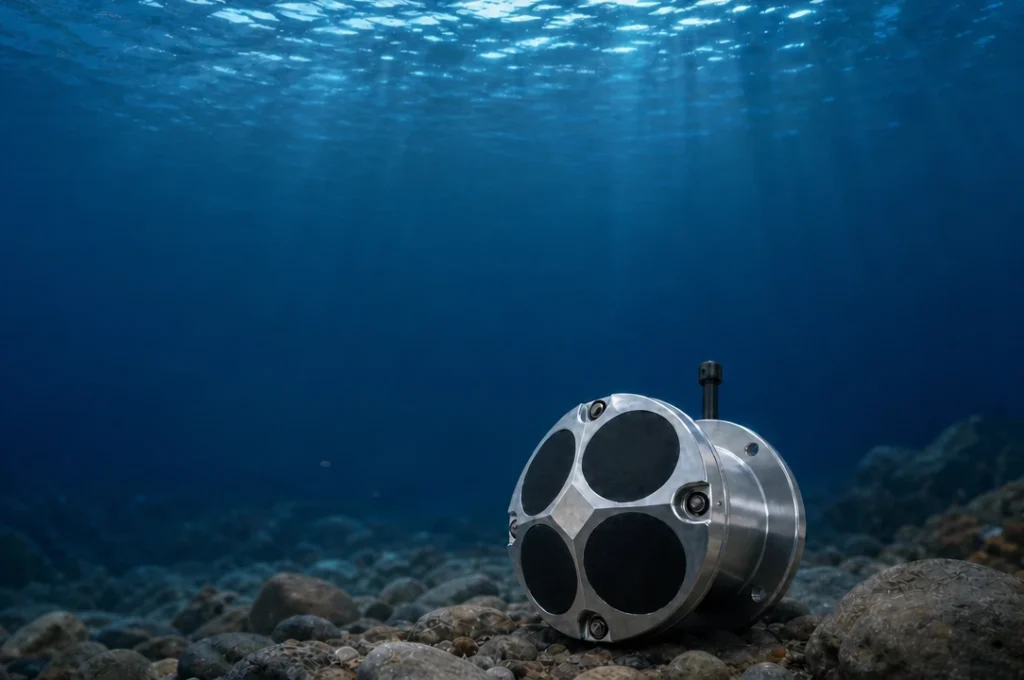
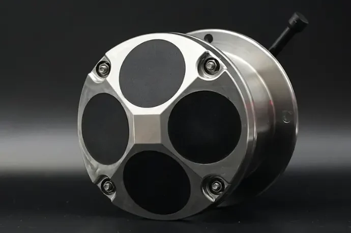
- Self-Contained Hydrophone — An underwater microphone for recording ambient sound, marine mammal vocalizations, vessel noise, and anthropogenic sound sources. Deployed autonomously for weeks to months.
- Towed Hydrophone Array — Linear arrays of hydrophones for directional acoustic monitoring, often used in marine mammal surveys and seismic exploration.
3. ADCP — The Workhorse of Current Measurement
Among all types of marine survey equipment, the Acoustic Doppler Current Profiler (ADCP) is arguably the most versatile. A single ADCP can replace an array of single-point current meters by measuring velocity at every depth simultaneously.
How ADCP Works
An ADCP transmits high-frequency acoustic pulses through 4 (or 5) angled transducer beams. These pulses reflect off particles naturally suspended in the water — plankton, sediment grains, bubbles. The frequency of the returning echo is shifted by the Doppler effect, and the magnitude of this shift is directly proportional to water velocity. By time-gating the returning signal into range bins, the ADCP resolves velocity at multiple depths — typically 50 to 200 layers — simultaneously.
For a complete technical explanation, read: Acoustic Doppler Current Profiler Working Principle.
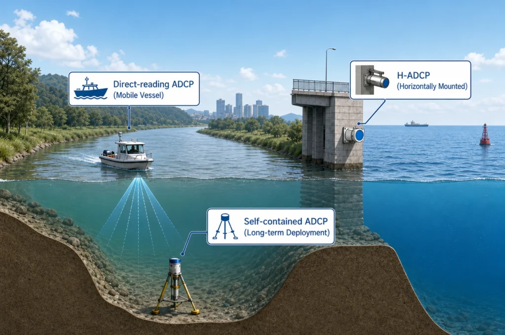
ADCP Configurations for Marine Survey
| Configuration | Deployment | Typical Survey Application |
|---|---|---|
| Direct-Reading ADCP | Vessel-mounted or cabled to shore | Hydrographic survey transects, real-time discharge measurement, offshore engineering surveys |
| Self-Contained ADCP | Bottom-mounted on mooring frame or seabed | Long-term ocean current monitoring, offshore wind resource assessment, scientific moorings |
| Horizontal ADCP (H-ADCP) | Side-looking, mounted on riverbank or bridge pier | River discharge monitoring, flood early-warning, irrigation canal management |
Browse Oceantek’s complete ADCP product range →
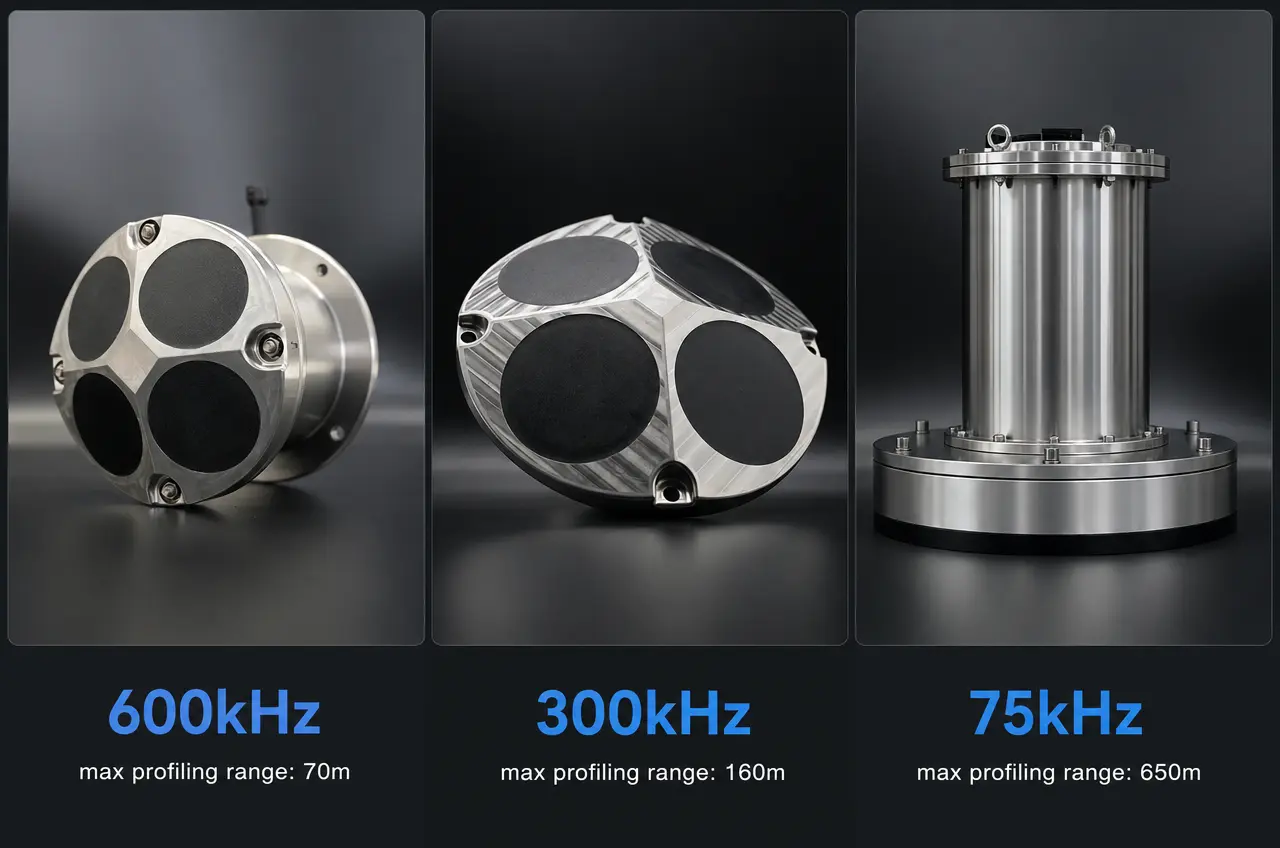
Frequency Selection for ADCP
The most important specification you will choose is operating frequency. Here is the practical rule:
| Frequency | Max Profiling Range | Typical Bin Size | Primary Use Case |
|---|---|---|---|
| 75 kHz | Up to 600–700 m | 8–16 m | Deep-ocean moorings, basin-scale circulation studies |
| 300 kHz | Up to 120–160 m | 2–4 m | Coastal oceanography, offshore wind, continental shelf |
| 600 kHz | Up to 50–75 m | 0.5–2 m | Rivers, estuaries, shallow coastal surveys, harbor monitoring |
For a complete discussion of frequency trade-offs: ADCP Frequency Selection: Complete Tutorial.
4. DVL — Doppler Velocity Logs for Underwater Navigation
A Doppler Velocity Log (DVL) is a specialized type of marine survey equipment that is optimized for vehicle velocity measurement rather than water current profiling. While a DVL shares the same underlying acoustic Doppler physics as an ADCP, it is engineered for a fundamentally different mission: telling an AUV or ROV exactly how fast and in what direction it is moving relative to the seabed.
DVL vs ADCP — The Key Distinction
| Characteristic | ADCP | DVL |
|---|---|---|
| Primary Output | Water velocity profile (current speed and direction at multiple depths) | Vehicle velocity vector (speed over ground in 3 axes) |
| Key Performance Metric | Water-profiling range | Bottom-track velocity accuracy at maximum altitude |
| Typical User | Hydrographer, oceanographer, hydrologist | AUV/ROV navigator, subsea engineer |
| Integration | Standalone or with GNSS for vessel surveys | Fused with INS via Kalman filter for subsea navigation |
For a comprehensive explanation: What Is a DVL? Difference Between DVL and ADCP.
DVL Selection Considerations
- Maximum altitude: How far above the seabed can the DVL hold bottom-lock? This determines the operational depth envelope of your AUV.
- Velocity accuracy: Typically ±0.2% to ±1%. For precision survey AUVs, accuracy under ±0.5% is essential.
- Size, weight, and power (SWaP): Critical for small AUVs and gliders where every watt and gram counts. Phased-array DVLs offer significant SWaP advantages over traditional piston designs.
- Integration protocol: Most DVLs output NMEA, binary, or Ethernet data to the vehicle’s INS. Verify protocol compatibility before purchasing.
Explore Oceantek DVL solutions →
5. Hydrophones & Passive Acoustic Monitoring Equipment
A hydrophone is an underwater microphone — a sensor that converts acoustic pressure variations in water into electrical signals. Hydrophones are the core sensing element for Passive Acoustic Monitoring (PAM), which has become a standard requirement in offshore construction, marine mammal research, and environmental compliance.
Self-Contained vs. Real-Time Hydrophones
| Type | Deployment | Best For |
|---|---|---|
| Self-Contained Hydrophone | Autonomous, internal battery and storage | Long-term ambient noise monitoring, marine mammal presence surveys, deep-ocean acoustics |
| Real-Time (Cabled) Hydrophone | Connected to surface via cable or telemetry buoy | Real-time PAM during piling operations, seismic mitigation monitoring, live marine mammal detection |
Key Hydrophone Specifications
- Frequency bandwidth: From a few Hz (seismic, whale calls) up to 100+ kHz (echolocation clicks of dolphins and porpoises). Select bandwidth to match your target sound sources.
- Sensitivity (dB re 1V/μPa): Higher sensitivity = quieter sounds detectable. Typical values range from -160 to -210 dB.
- Self-noise: The hydrophone’s own electronic noise floor. Must be lower than the ambient noise you are trying to measure.
- Depth rating: 200 m (coastal) to 6000+ m (full ocean depth).
Explore Oceantek Self-Contained Hydrophones →
6. Supporting Instruments in Marine Survey
6.1 CTD — Conductivity, Temperature, Depth
The CTD is the most fundamental oceanographic sensor after the ADCP. It provides the sound speed profile required to correct multibeam echosounder data, the density profile for understanding water mass structure, and environmental context for every other measurement. Many modern ADCPs integrate CTD sensors directly into the instrument housing.
6.2 Multibeam and Side-Scan Sonar
While ADCPs measure water velocity, multibeam echosounders measure seabed geometry. A complete hydrographic survey typically deploys both simultaneously: the ADCP mounted on the vessel hull or pole, the multibeam mounted alongside or through the hull. Side-scan sonar complements multibeam by providing high-resolution acoustic imagery of the seabed surface, revealing objects and textures that bathymetry alone misses.
6.3 Single-Point Current Meters
For applications where a full velocity profile is unnecessary — or where budget constraints prevent deploying an ADCP — single-point current meters offer a cost-effective alternative. They measure velocity at one depth and are often deployed in arrays to approximate a profile. Browse Oceantek single-point current meters →
7. How to Select Marine Survey Equipment — A Practical Framework
Given the diversity of marine survey equipment available, a structured selection process prevents costly mistakes. Here is a five-step framework used by experienced survey planners:
Step 1: Define Your Measurement Parameters
What specifically do you need to measure? Be precise:
- Current velocity? → ADCP
- Vehicle navigation velocity? → DVL
- Seabed depth and morphology? → Multibeam / Single-beam echosounder
- Underwater sound? → Hydrophone
- Water properties (salinity, temperature)? → CTD
- Flow at a single point? → Single-point current meter
Step 2: Determine Water Depth and Range Requirements
Water depth dictates frequency. Use the ADCP frequency table in Section 3 as a starting point. For DVLs, your maximum operating altitude determines the minimum frequency. For hydrophones, depth rating is the primary constraint.
Step 3: Decide Deployment Type
- Vessel-mounted (real-time): For surveys where data is needed immediately and a vessel is available.
- Autonomous (self-contained): For long-duration deployments without surface presence. Requires internal power and data storage.
- Fixed-platform (cabled): For permanent monitoring stations with shore power and real-time data telemetry.
- Vehicle-integrated (DVL): For AUV/ROV navigation. Must meet SWaP constraints and INS protocol requirements.
Step 4: Verify Integration and Data Compatibility
Marine survey equipment rarely operates in isolation. Ensure compatibility with:
- Positioning systems (GNSS, USBL)
- Motion reference units (MRU/AHRS)
- Data acquisition software (Hypack, QINSy, WinRiver, custom solutions)
- Post-processing workflows (QRev, MATLAB, Python)
Step 5: Evaluate Total Cost of Ownership
Beyond the purchase price, factor in:
- Calibration costs and intervals
- Deployment hardware (mounting frames, cables, buoys)
- Spare parts and consumables (O-rings, connectors, batteries)
- Software licenses and upgrades
- Training requirements
- Expected service life and manufacturer support quality
For a deeper parameter-level selection guide: Which Key Parameters Need to Be Considered When Selecting an ADCP?
8. Oceantek Marine Survey Equipment at a Glance
| Product Category | Available Configurations | Primary Application |
|---|---|---|
| Direct-Reading ADCP | 300 kHz FA4, 600 kHz FA4, 75 kHz PA4 | Vessel-mounted real-time current profiling |
| Self-Contained ADCP | 300 kHz FA4, 600 kHz FA4, 75 kHz PA4 | Autonomous mooring and long-term monitoring |
| River-Type ADCP | River ADCP M9, HADCP-600 | River discharge, flood monitoring, canal management |
| DVL | 300 kHz FA4, 600 kHz FA4, 600 kHz PA5 | AUV/ROV navigation, subsea positioning |
| Self-Contained Hydrophone | H3-OCEAN-6000 | Passive acoustic monitoring, marine mammal surveys |
| Single-Point Current Meter | Ocean-SPCM | Point velocity monitoring, budget-conscious deployments |
View all products and technical specifications →
9. Frequently Asked Questions About Marine Survey Equipment
What is the difference between marine equipment and marine survey equipment?
Marine equipment is a broad term covering all hardware used in marine environments — ships, engines, deck machinery, navigation systems, safety gear, and more. Marine survey equipment is a specific subset: scientific instruments designed for measuring, mapping, and monitoring the ocean. ADCPs, multibeam echosounders, CTDs, hydrophones, and DVLs all fall under marine survey equipment.
Can one marine survey instrument measure everything?
No. Each instrument is optimized for specific parameters. An ADCP measures velocity, not bathymetry. A CTD measures water properties, not currents. A hydrophone measures sound, not depth. In practice, marine surveys deploy multiple instruments simultaneously — often on the same vessel, mooring, or vehicle — to capture a complete picture of the marine environment. Modern instruments increasingly share data through integrated acquisition systems, but no single sensor can replace a well-planned multi-instrument survey.
Which marine survey equipment do I need for a hydrographic survey?
A standard hydrographic survey requires: (1) a multibeam or single-beam echosounder for bathymetry, (2) an ADCP for current profiling to correct vessel motion and understand flow conditions, (3) a CTD or sound velocity profiler for sound speed correction, and (4) a GNSS positioning system for georeferencing. Additional instruments (side-scan sonar, sub-bottom profiler, hydrophone) are added depending on specific survey objectives.
Further Reading
- What Is an ADCP Sensor? Complete Technical Guide
- Acoustic Doppler Current Profiler Working Principle
- What Is a DVL? Difference Between DVL and ADCP
- ADCP Frequency Selection: 75kHz vs 300kHz vs 600kHz
- Key Parameters to Consider When Selecting an ADCP
- ADCP vs Traditional Current Meter: Which Is Better?
- ADCP Applications in River Discharge Measurement: Complete Guide
- 2026 Global ADCP Industry White Paper