Executive Summary
The 1960 Indus Waters Treaty is one of the world’s oldest continuously operating transboundary water agreements — and it has always been, at its technical core, a flow-data treaty. Article VI obliges daily observation and monthly exchange of river discharges; Article VIII created the Permanent Indus Commission; flood-season telemetry has moved between the two sides for six decades. In 2025 that data machinery entered its deepest crisis: India declared the treaty held in abeyance (23 April 2025), while the World Bank-appointed Neutral Expert ruled on 20 January 2025 that he has jurisdiction over all seven objections in the Kishenganga–Ratle dispute and later rejected Pakistan’s bifurcation application. This article maps the treaty’s measurement mechanisms, the rulings, the Shahpurkandi completion on the Ravi, and what flow monitoring each future scenario demands. Written strictly from a measurement-engineering perspective; positions of both governments are attributed to their stated sources.
Table of Contents
- The Treaty and Its Rivers
- The Measurement Machinery: Article VI, the PIC and Flood Data
- The 2025 Rupture: ‘In Abeyance’ and What Suspended
- The Neutral Expert’s Rulings: Kishenganga and Ratle
- Shahpurkandi and the Eastern Rivers
- The Channel That Survived: Humanitarian Flood Warnings
- What Flow Monitoring Each Scenario Demands
- FAQ
1. The Treaty and Its Rivers
Signed in 1960 and brokered by the World Bank, the Indus Waters Treaty divides the Indus system into two baskets: the three western rivers — Indus, Jhelum and Chenab — whose waters Pakistan uses, with limited Indian rights for non-consumptive and run-of-river uses; and the three eastern rivers — Ravi, Beas and Sutlej — whose waters India uses, subject to defined transitional arrangements. Most disputes since 1960 have turned on a single technical question: whether Indian projects on the western rivers store too much water — the “pondage” question at the heart of the current Kishenganga–Ratle case.
For hydrometry professionals, the treaty matters because it is not a political document alone; it is an operating manual for a measurement network. Its provisions specify who observes what, at which stations, on what schedule, and to whom the records go. Even the current rupture is, in large part, a story about which data channels stopped and which ones kept flowing.
2. The Measurement Machinery: Article VI, the PIC and Flood Data
Article VI (Exchange of Data) obliges the two sides to maintain hydrological observation stations and to exchange daily records of water levels and discharges, compiled and transmitted on a monthly basis. Article VIII establishes the Permanent Indus Commission (PIC) — one commissioner from each country — as the standing channel for implementation, inspection and dispute avoidance. A detailed legal analysis of this regime is available in the ISSRA review of the treaty’s data-exchange regime.
On top of the monthly Article VI flow, the flood season has historically run a faster channel: India supplies daily — and during floods hourly — river data for the six treaty rivers to Pakistan’s flood-forecasting cell, using warning thresholds accumulated over decades of PIC practice. The key published thresholds (ISSRA):
| Station | River | Flood-warning threshold |
|---|---|---|
| Akhnoor | Chenab | 300,000 cusecs (≈8,495 m³/s) |
| Madhopur | Ravi | 200,000 cusecs (≈5,663 m³/s) |
| Ferozepur | Sutlej | 150,000 cusecs (≈4,248 m³/s) |
| Jammu | Tawi | 75,000 cusecs (≈2,124 m³/s) |
Each threshold is a discharge measurement, not a water-level reading — which is why the treaty’s data obligations have always implied a maintained, calibrated gauging capacity on both sides of each section.
3. The 2025 Rupture: ‘In Abeyance’ and What Suspended
The treaty’s institutional machinery stopped in stages during 2025. On 23 April 2025, a day after the Pahalgam attack, India’s Cabinet Committee on Security decided to hold the treaty in abeyance — India’s own term, distinct from termination. What that suspension covered, per Indian reporting: PIC meetings, joint inspections and routine data exchange. India’s stated condition for resumption, reported in August 2025, is that Pakistan must “credibly and irreversibly” abandon support for cross-border terrorism (The Statesman). In February 2026, Pakistan’s side stated that routine water-level and flow data exchange had by then been stalled for about two years.
In parallel, the arbitration track continued. The Permanent Court of Arbitration — whose process India has not participated in, on the basis that the Neutral Expert mechanism is the correct forum — issued rulings in June and August 2025 to the effect that the treaty can only be terminated by mutual consent (ICWA analysis of India’s notices). Pakistan’s prime minister stated in August 2025 that “every drop is our red line,” and India’s Ministry of External Affairs reiterated that its position remains unchanged (Outlook India; Livemint). For the purposes of this article, the operational consequence is singular: the routine Article VI channel is down, and the questions of when — and under what rules — it resumes are open.
4. The Neutral Expert’s Rulings: Kishenganga and Ratle
The technical dispute predates the political rupture. Pakistan raised objections to two Indian run-of-river projects on western rivers: Kishenganga (330 MW) on the Kishenganga/Neelum tributary of the Jhelum, and Ratle (850 MW) on the Chenab. At the core of the objections are design parameters — freeboard, spillway configuration and especially pondage, i.e., how much live storage a nominally run-of-river plant may hold.
Two rulings frame 2025. On 20 January 2025, the Neutral Expert — Michel Lino, ICOLD president, appointed by the World Bank in October 2022 — ruled that he has jurisdiction over all seven of Pakistan’s objections under Annexure F, paragraph 7 (official press release, PCA case files). On 18 December 2025, he rejected Pakistan’s application to split the proceedings, ruling that issues such as pondage must be assessed in the whole. The substantive phase now proceeds with India participating in the Neutral Expert process (background: Indian Express explainer).
5. Shahpurkandi and the Eastern Rivers
While the western-river case advanced in The Hague, India completed a long-pending eastern-river project. The Shahpurkandi barrage on the Ravi — on the Punjab–Jammu & Kashmir border, roughly 11 km downstream of the Ranjit Sagar dam — was completed in February 2024, after a history stretching from a 1995 foundation to a 2018 restart. The engineering profile, per Daily Excelsior and Deccan Herald: 55.5 m high, irrigating about 32,000 hectares in Kathua and Samba districts of J&K, with two powerhouses totalling 206 MW and a revised cost of roughly ₹3,300 crore. Media reports state it retains approximately 1,150 cusecs of Ravi flow that previously continued downstream — a figure widely reported across Indian outlets, noted here as reported rather than from official engineering documents.
Hydrologically, Shahpurkandi is the completion of India’s eastern-river infrastructure under the treaty’s own framework — the eastern rivers are allocated to India’s use — and its operational consequence for measurement is straightforward: the retained flow, the irrigation releases and the powerhouse discharges now constitute an eastern-river utilisation record that, under any revived or renegotiated regime, must be measured and documented at the section.
6. The Channel That Survived: Humanitarian Flood Warnings
One data channel remained open through the rupture. Even with routine exchange suspended, India continued to transmit humanitarian flood warnings — 23 in total during 2025 — including a 24–25 August 2025 warning for the Tawi river delivered through diplomatic channels, reported as the first such contact since the May 2025 escalation (News18).
Why this matters technically: flood warnings are threshold-triggered discharge events — they exist because the Akhnoor, Madhopur, Ferozepur and Jammu gauges still measure, and because someone still compares the readings against the historical thresholds. The humanitarian channel is evidence that the treaty’s measurement infrastructure is still alive even while its institutional wrapper is suspended — and that its restoration is a data problem as much as a diplomatic one.
7. What Flow Monitoring Each Scenario Demands
Whatever path the treaty takes, each scenario has a concrete measurement footprint:
| Scenario | Measurement demand | Instrument class |
|---|---|---|
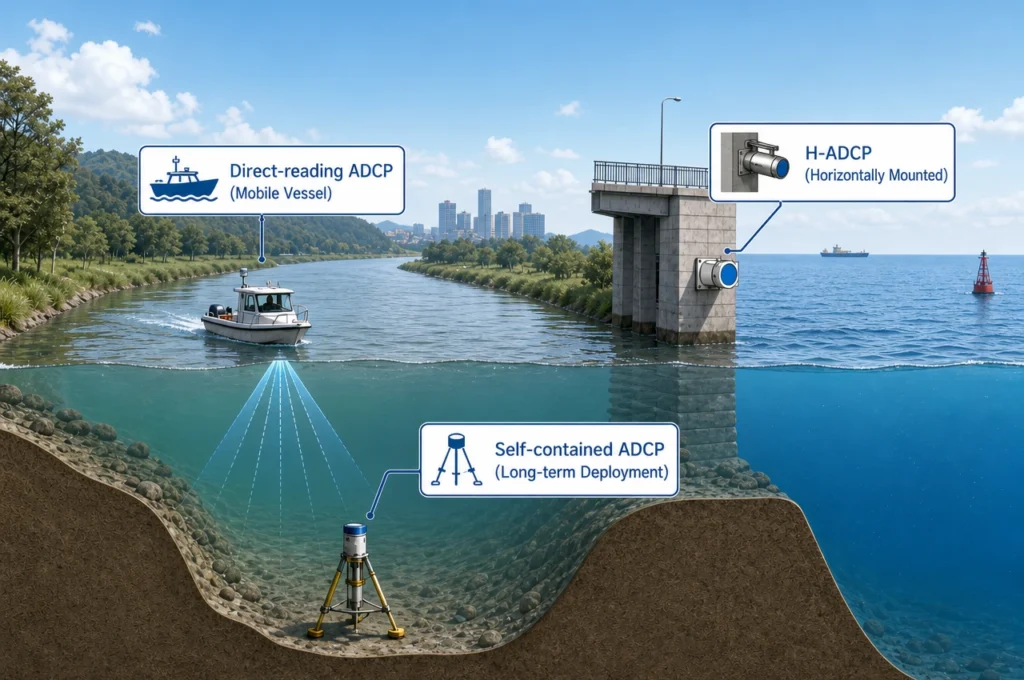
| Status quo / abeyance continues | Unilateral Indian gauging continues for flood warnings and eastern-river utilisation records | Fixed H-ADCP stations + maintained rating curves |
| Neutral Expert substantive rulings | Verified inflow, pondage and reservoir-level records for Kishenganga and Ratle presented as evidence | Moving-boat ADCP (ISO 24578:2021 method) + continuous inflow gauging |
| Renegotiation | Restored Article VI daily exchange, jointly calibrated sections, possibly third-party verification | Profiler fleet at treaty sections + telemetry integration |
| Eastern-river utilisation accounting | Shahpurkandi and related release records, irrigation and power discharges | ADCP + fixed stations at barrage sections |
The buyer set on the Indian side is concrete: the Central Water Commission for the treaty-adjacent gauging network, NHPC as Ratle’s developer, CVPP/J&K power corporations for Kishenganga-class operations, and the verification consultants who prepare hydro-technical evidence for arbitral proceedings. For these buyers, the requirement is invariant across scenarios: discharge records that survive adversarial scrutiny — profiler-class accuracy, documented methods under ISO 24578:2021, and continuous fixed-station series that nobody’s lawyers can poke a hole in.
FAQ
What flow-data obligations does the Indus Waters Treaty impose?
Article VI requires daily observation and monthly exchange of water levels and discharges at specified stations; Article VIII created the Permanent Indus Commission as the standing channel. During flood season, India has historically supplied daily — and hourly during floods — river data for the six treaty rivers to Pakistan’s flood cell (ISSRA analysis).
What did the Neutral Expert rule in 2025?
On 20 January 2025, Neutral Expert Michel Lino ruled he has jurisdiction over all seven of Pakistan’s objections concerning Kishenganga (330 MW) and Ratle (850 MW); on 18 December 2025 he rejected Pakistan’s bifurcation application (PCA press release).
Why is India’s position on the treaty described as ‘in abeyance’?
India’s Cabinet Committee on Security decided on 23 April 2025, following the Pahalgam attack, to hold the treaty in abeyance and suspend PIC meetings, joint inspections and routine data exchange. India has stated resumption requires Pakistan to credibly and irreversibly abandon support for cross-border terrorism (The Statesman).
What did the Shahpurkandi barrage change on the Ravi?
Completed in February 2024, the 55.5 m barrage retains a reported ~1,150 cusecs, irrigates about 32,000 hectares in Kathua and Samba districts, and adds 206 MW of generation at a revised cost of about ₹3,300 crore (Daily Excelsior).
What role would ADCPs play in treaty-era flow monitoring?
Verification-grade discharge at treaty sections, flood-threshold stations, and eastern-river utilisation records. Moving-boat ADCPs following ISO 24578:2021 build and maintain the rating curves; fixed H-ADCP stations deliver the continuous series that threshold-based flood warnings depend on.
Sources: All figures in this article are drawn from the following documents and reports, cited inline above.
- Permanent Court of Arbitration — Neutral Expert press release, jurisdiction ruling (20 Jan 2025)
- Indian Express — explainer on the Neutral Expert’s jurisdiction decision
- The Statesman — India holds treaty in abeyance; resumption conditions
- ICWA — analysis of India’s Article XII(3) notices and treaty process
- Outlook India — Pakistan PM’s statement, August 2025
- Livemint — MEA: India’s position unchanged
- Daily Excelsior — Shahpurkandi completion, 32,000 ha irrigation (Feb 2024)
- Deccan Herald — Ravi flow retention reporting
- ISSRA — treaty data-exchange regime: Article VI/VIII and flood-warning thresholds
- News18 — 23 flood warnings in 2025; Tawi warning of 24–25 Aug 2025
- PLOS Water (2025) — research on treaty public discourse (background)
Disclosure: OceanADCP is a brand of Oceantek Marine Technology. This article describes publicly documented treaty mechanisms, rulings and engineering facts for educational purposes. It takes no position on the claims of either government, and is not affiliated with the Governments of India or Pakistan, the World Bank, the Neutral Expert or the Permanent Court of Arbitration. The 1,150 cusecs figure for Shahpurkandi is presented as reported by Indian media, not as an official engineering value.
© 2026 Ocean (Hangzhou) Technology Co., Ltd. All rights reserved. Last updated: September 8, 2026.