Executive Summary
On 7 September 2024, Typhoon Yagi — the strongest storm to hit Vietnam in 30 years — made landfall and set off the most dangerous reservoir crisis in the country’s modern history. At Thac Ba reservoir, inflow peaked at 5,620 m³/s against a design discharge capacity of 3,230 m³/s. The water rose to 59.84 m — just 1.36 m below the 61 m threshold at which the Prime Minister had authorized breaching auxiliary dam No. 4, with 3,186 households evacuated in four hours. In Hanoi, the Red River peaked at about 11.1–11.3 m at Long Bien, the highest since 2004, and held behind a 626 km dike system. This article reconstructs the 48-hour crisis, the design decisions that created it, and the monitoring reforms Vietnam has since launched — the context every flood-instrument supplier needs to understand Vietnam’s post-Yagi market.
Table of Contents
- The Storm That Changed Vietnam’s North
- The Red River Rises: Hanoi’s Highest Flood Since 2004
- Thac Ba: The 48 Hours That Nearly Ended in a Dam Breach
- Why the Reservoir Nearly Failed
- What Held: Dikes, Forecasts and the 24-Hour Rule
- The Reforms: Decision 922 and the Monitoring Overhaul
- The Measurement Gaps the Crisis Exposed
- FAQ
1. The Storm That Changed Vietnam’s North
Typhoon Yagi made landfall in Quang Ninh and Hai Phong on 7 September 2024 with gusts exceeding 149 km/h — the strongest typhoon to strike Vietnam in three decades, according to Vietnam Investment Review. The coastal destruction was only the first act. The storm’s rainbands parked over the northern mountains, feeding the Thao, Lo-Gam and Thai Binh river systems, and the flood wave that followed pushed nearly every major northern river to record levels.
The final toll, per official figures reported by Sai Gon Giai Phong:
| Indicator | Value |
|---|---|
| Fatalities | 318 dead, 26 missing, ~1,900 injured |
| Economic damage | ~VND 81,000 billion (≈US$3.3 billion), 0.62% of 2023 GDP |
| Provinces affected | 26 |
| Houses damaged | 282,000+ |
| Dike incidents | 796 reported nationally |
| Irrigation & water works damaged | 3,500+ |
| GDP impact | -0.15 percentage points for 2024 (MPI estimate) |
For Vietnam’s hydrology sector, Yagi was not just a disaster — it was an audit of the entire flood-management system: the reservoirs, the operating rules, the dikes and, crucially, the measurement network that informed every decision made during those 48 hours.
2. The Red River Rises: Hanoi’s Highest Flood Since 2004
The flood wave reached Hanoi’s Long Bien gauging station on the Red River in steps that the whole city could watch:
- 10 September, 11:10 — the station hit 9.5 m, triggering Alert Level I (Level II = 10.5 m, Level III = 11.5 m).
- 10 September, 15:00 — the 122-year-old Long Bien Bridge was fully closed to vehicles and pedestrians, and heavy vehicles were barred from Chuong Duong Bridge (report).
- 11–12 September — the river peaked at approximately 11.1–11.3 m (gauge records include 11.14 m at 13:00 on 11 September), rising at a peak rate of about 10 cm/hour — just 0.2–0.4 m below Alert Level III, the highest level since 2004 according to NCHMF director Mai Van Khiem.
Upstream, the picture was even more extreme. The Thao River at Lao Cai station reached 87.27 m on 9 September — exceeding the record set in 1971 — and VnExpress reported that several northern rivers posted their highest levels in over five decades.
2.1 Why Hanoi stayed dry behind its dikes
Hanoi’s flood defenses — the oldest continuously maintained river engineering system in Southeast Asia — absorbed the event. The city maintains more than 626 km of classified dikes across seven river systems, of which the right-bank Red River dike is special-class, running 37.7 km and directly shielding the city core, per Hanoi’s agriculture and dike authority. No main dike breached during Yagi — flooding was confined to the unprotected floodplain outside the dikes, such as Phuc Xa sandbar (Ba Dinh district) and Yen Phu ward (Tay Ho), where thousands of riverside residents were evacuated and boats became the only transport. Hanoi recorded three direct deaths, and northern provinces reported 23 dike incidents that were contained (SGGP).
The dike system is why NCHMF director Mai Van Khiem could state publicly that the inner city would remain safe even at Level III. The question the storm raised was not whether the dikes would hold — it was whether the reservoirs upstream would.
3. Thac Ba: The 48 Hours That Nearly Ended in a Dam Breach
Thac Ba reservoir sits on the Chay River in Yen Bai province — one of Vietnam’s oldest hydropower reservoirs, commissioned in 1971 with a 120 MW plant, a main dam and 18 auxiliary dams. Its spillway and bottom outlets were designed to discharge a maximum of 3,230 m³/s, sized for a design flood with an inflow peak of 5,100 m³/s. The reconstruction below follows VOV’s detailed post-crisis account.
3.1 The timeline
| Date (2024) | Event |
|---|---|
| Sep 3–6 | Pre-release through 2 gates at ~270 m³/s, draining the reservoir ahead of the storm |
| Sep 6–9 | Release raised to 1,000 m³/s for three consecutive days — cumulative pre-release exceeding 200 million m³ |
| Sep 10 | Inflow peak of 5,620 m³/s — 74% above the 3,230 m³/s design discharge capacity and above the 5,100 m³/s design flood |
| Sep 11, 05:00 | Water level peaks at 59.84 m — 1.36 m below the 61 m critical threshold — with all three bottom outlets open and still unable to control the rise |
| Sep 11 | Inflow falls to 3,180 m³/s; the worst case is averted |
3.2 The breach plan
With the level still climbing past 59 m, the Prime Minister authorized an emergency contingency: if the reservoir reached 61 m, engineers would breach auxiliary dam No. 4 to save the main dam. Military engineering units had already drilled the auxiliary dam and placed explosive charges. Downstream, 3,186 households — 11,279 people — were evacuated in four hours as the army and local authorities cleared the flood path. The margin between a controlled, survivable flood event and a catastrophic dam break was 1.36 meters of water level.
Thac Ba was not alone. Five hydropower reservoirs pre-released simultaneously before landfall, and Tuyen Quang hydropower opened its entire bottom sluice gates during the event. By November 2024, the National Assembly heard that Yagi had severely damaged 68 reservoirs, taking the national total of severely damaged reservoirs to 408 — with no repair funds yet allocated at that time (VTV).
4. Why the Reservoir Nearly Failed
The near-miss was not bad luck; it was the predictable collision of three structural weaknesses, all documented in the post-crisis expert review (Tien Phong’s review of the expert critiques):
- End-of-season full storage. Under the existing operating rules, reservoirs entered September at 80–90% of design water level — the flood-control buffer had largely been consumed by storage for the dry season, leaving almost no capacity to absorb an extraordinary event.
- Fixed-threshold operating rules. Releases were triggered by rigid water-level thresholds tied to historical hydrology, not by forecasts of the rainfall actually approaching. When Yagi’s rain concentrated over the Thao, Lo-Gam and Thai Binh basins — not the Da basin where the biggest dams sit — the rulebook had no mechanism to respond early enough.
- Capacity designed for a different climate. Thac Ba’s 3,230 m³/s discharge capacity was sized for a 5,100 m³/s design flood. Yagi delivered 5,620 m³/s. Across the north, only 23 of 3,153 reservoirs had pre-release capability before the disaster, and only about 19% of reservoirs had monitoring equipment at all (Vietnam News).
5. What Held: Dikes, Forecasts and the 24-Hour Rule
Two systems performed under pressure. The first was the dike network (Section 2). The second was the reservoir dispatch framework built around the Red River’s hydraulic reality: flood water takes about 24 hours to travel from Hoa Binh reservoir to Hanoi.
Under Decision 740/QD-TTg (2019), the entire cascade is operated against a single control variable: the 24-hour forecast water level at Hanoi. The rules define three flood-control levels — keep Hanoi below 11.5 m, 12.0 m or 13.1 m, corresponding to reservoir level ceilings of 100 m, 108 m and 120 m at Hoa Binh — with a final “dam-protection mode” (release not exceeding inflow) if both thresholds are breached. The system is supervised through MARD’s online platform tracking 134+ reservoirs hourly across 11 river basins, and EVN’s telemetry network reports every 2 hours in normal operation and every 15 minutes during releases.
That framework is exactly what contained Yagi’s downstream consequences — and exactly what the event proved insufficient at the margins, because it optimized for the Da basin hydrology that Yagi did not follow.
6. The Reforms: Decision 922 and the Monitoring Overhaul
Vietnam’s response was fast. On 14 May 2025, the government issued Decision 922/QD-TTg amending the Red River inter-reservoir operating rules — adding transition-period and storage-period provisions and moving the framework toward flexible operation informed by 5–10-day medium-range forecasts instead of rigid historical thresholds. Experts had explicitly called for exactly this: fixed thresholds plus full late-season storage created the Thac Ba trap (Tien Phong).
The monitoring layer is being rebuilt alongside the rules:
- Reservoir monitoring: expansion of the MARD online system beyond its current 134+ reservoirs, targeting the ~81% of reservoirs that still lack instrumentation.
- Operator telemetry: EVN’s plans to procure 50 additional rain gauges, 16 hydrological stations and radar data feeds for Da and Gam river cascade operations (EVN operational updates).
- Early-warning modernization: international partnerships launched after Yagi — Weathernews’ AI flood forecasting MOU with NCHMF (July 2025), Belgium’s Flood4Cast deployment in Da Nang (June 2026), and a national network of ~140 smart flood-warning towers and ~2,800 rain gauges (VCCI).
- Dam safety law update: a new decree is being drafted with new requirements for hydro-meteorological instrumentation, downstream flood maps and a national dam database (Vietnam.vn).
7. The Measurement Gaps the Crisis Exposed
For instrumentation suppliers, the Yagi crisis is a precise map of Vietnam’s measurement deficits. Three gaps mattered most during the event:
7.1 Inflow measurement at reservoirs
Thac Ba’s operators knew the level, but inflow had to be inferred from level change and upstream gauges — during the fastest-rising phase of the flood, the inference lagged the reality. Direct inflow gauging at reservoir headwater sections, feeding the dispatch decision every 15 minutes, is the operational fix the reform documents now demand.
7.2 Discharge at downstream control sections
The entire Decision 740/922 framework pivots on Hanoi’s 24-hour forecast level — which is only as good as the discharge measurements building the rating curves upstream. During Yagi, several northern gauging sections were destroyed or bypassed at exactly the moment their data were needed. Post-flood, the priority is hardened, redundant, real-time sections.
7.3 Measuring extreme, sediment-laden flows
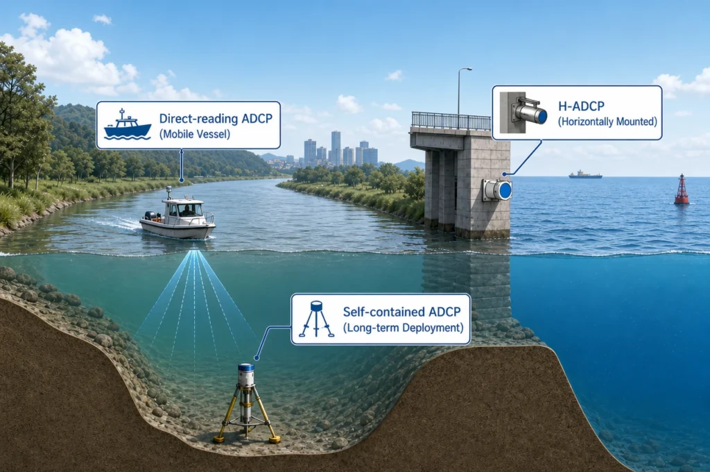
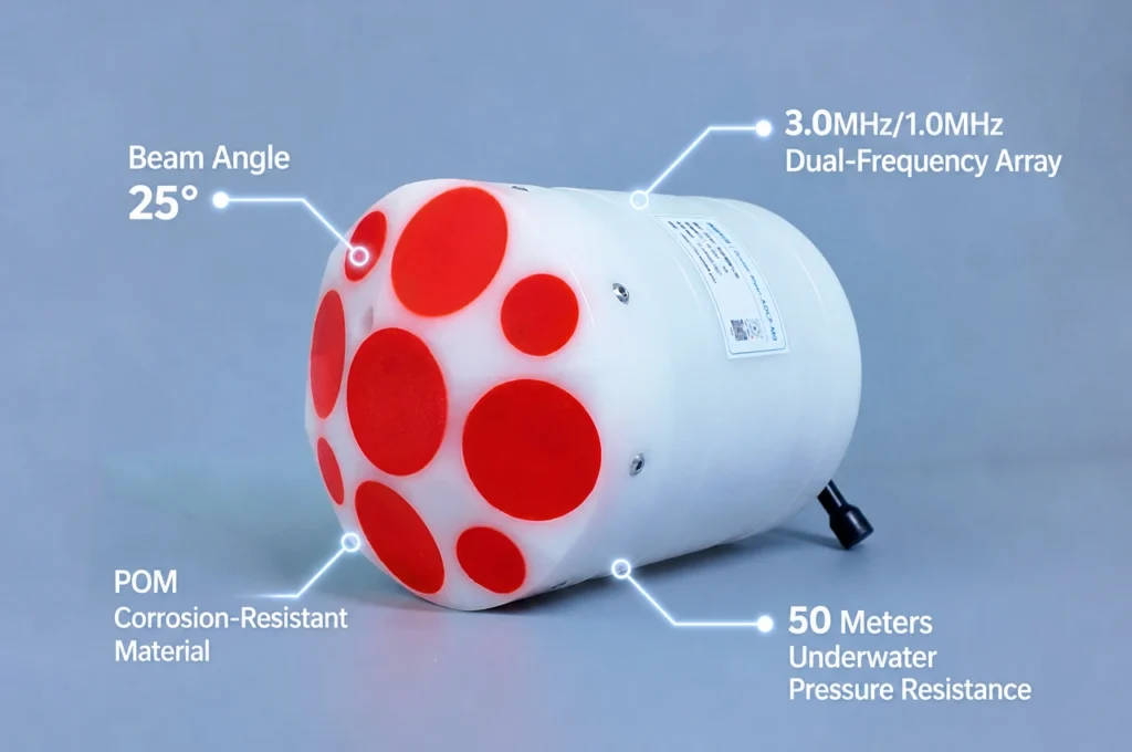
This is where ADCP class instruments earn their place. The Red River system carries suspended sediment routinely above 500 mg/L — field accounts from the Phu Tho reach document acoustic signal attenuation strong enough to degrade profilers not designed for it, plus riverbeds that step from 4 m to 22 m within 30 m of channel . A 600 kHz profiler with bottom-tracking and moving-bed correction measures the full section in minutes, works at night, and survives the turbidity that defeats lighter instruments — the profile of the River-ADCP-600-FA5 (±0.25% ±2 mm/s, integrated GPS). Fixed H-ADCP stations complete the picture at permanent control sections, streaming continuous discharge where crews cannot safely work.
For the wider early-warning context these measurements feed, see our guide to ADCP-based flood early warning architecture.
FAQ
Why was Thac Ba Reservoir so close to failure during Typhoon Yagi?
Thac Ba’s spillway and bottom outlets were designed to discharge 3,230 m³/s, but on 10 September 2024 the reservoir received a record inflow peak of 5,620 m³/s — 74% above design capacity. The reservoir was also nearly full under end-of-season storage rules. The level peaked at 59.84 m, just 1.36 m below the 61 m threshold at which the Prime Minister had authorized breaching auxiliary dam No. 4 (VOV account).
How high did the Red River rise in Hanoi during Typhoon Yagi?
The Long Bien station hit 9.5 m (Alert Level I) on 10 September and peaked at approximately 11.1–11.3 m on 11–12 September — just 0.2–0.4 m below the 11.5 m Level III — the highest since 2004 (NCHMF director). Several northern rivers recorded 50-year highs.
Why didn’t Hanoi flood despite the record levels?
Hanoi’s 626+ km classified dike system — including the 37.7 km special-class right-bank Red River dike — held without a single main-dike breach. Flooding was confined to the unprotected floodplain (Phuc Xa, Yen Phu), and Hanoi recorded three direct deaths (SGGP).
What changed in Vietnam’s flood operations after Typhoon Yagi?
Decision 922/QD-TTg (May 2025) shifted the Red River cascade toward flexible, forecast-based operation using 5–10-day predictions instead of fixed thresholds. Monitoring investment followed: the MARD online platform now tracks 134+ reservoirs, EVN is procuring 50 rain gauges and 16 hydrological stations, and a new dam-safety decree adds instrumentation requirements.
How do ADCPs fit into Vietnam’s post-Yagi flood monitoring?
Yagi exposed three gaps: real-time inflow measurement at reservoirs, hardened discharge gauging at downstream control sections, and the ability to measure extreme, sediment-laden flows (500+ mg/L) continuously. A 600 kHz ADCP profiles the full section in minutes with moving-bed correction, and fixed H-ADCP stations stream continuous discharge where crews cannot work — together closing the data loop that Thac Ba’s operators lacked.
Sources: All figures in this article are drawn from the following primary and press documents, cited inline above with their institution and date.
- Sai Gon Giai Phong — Typhoon Yagi toll: 318 dead, US$3.3 billion damage (Sept 2024)
- VOV World — MPI: Yagi cut 2024 GDP growth by 0.15 percentage points
- VOV Live — Thac Ba crisis reconstruction: 5,620 m³/s inflow, 59.84 m peak, breach plan
- Baochinhphu — Red River flood level and alert thresholds, 12 Sept 2024
- VnExpress — NCHMF director: Red River highest since 2004, dikes protect Hanoi
- VnExpress — Northern rivers at 50-year highs; Thao River beats 1971 record
- Hanoi dike authority — 626 km dike system and VND 35,000 billion upgrade plan
- SGGP — Dike incidents and protection during Yagi
- VOV Live — Five hydropower reservoirs pre-released before Yagi landfall
- SGGP — Tuyen Quang opens entire bottom sluice gates
- VTV — 408 severely damaged reservoirs nationwide (National Assembly, Nov 2024)
- Tien Phong — Expert critique: revise fixed-threshold inter-reservoir rules after Thac Ba
- Vietnam News — Only ~19% of reservoirs have monitoring equipment
- Vietnam.vn — Red River inter-reservoir operating rules (Decision 740 framework)
- Vietnam.vn — Decision 922/QD-TTg (14 May 2025) amending reservoir rules
- Cong Luan — MARD online platform tracks 134+ reservoirs across 11 basins
- EVN — Yagi operational updates: telemetry cadence and 50 rain gauges / 16 stations plan
- VCCI — 140 smart flood-warning towers, 2,800 rain gauges nationwide
- Weathernews — AI flood forecasting MOU with NCHMF (July 2025)
- MARD VDDMA — Flood4Cast extreme-rainfall platform, Da Nang (2026)
- ADCP operations in the sediment-laden Phu Tho reach of the Red River
Disclosure: This article reconstructs publicly documented events of Typhoon Yagi for educational purposes; it is not affiliated with or endorsed by the Government of Vietnam, EVN or NCHMF. Water-level figures follow the ranges reported by the cited sources (Long Bien peak approximately 11.1–11.3 m).
© 2026 Ocean (Hangzhou) Technology Co., Ltd.,All rights reserved. All rights reserved. Last updated: August 27, 2026.